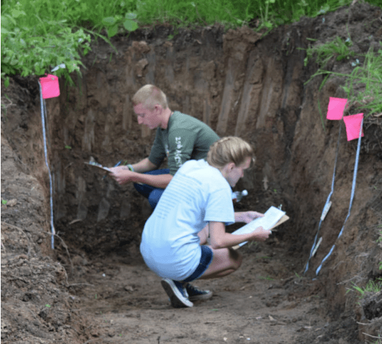
 There can be many uses of the word “soil”, depending upon the context. For example, soil can be thought of as an engineering material for road construction, as dirt on clothing, as a mixture of ingredients for growing potted plants, or what the farmers plow every spring.
For the purposes of the regional Envirothon, “Soil is the collection of natural bodies on the earth’s surface, in places modified or even made by man of earthy materials, containing living matter and supporting or capable of supporting plants out-of-doors.” Soil is thus considered both a product of nature and a critical part of natural systems. This definition also allows soils to be collectively grouped into a classification system, as used in making soil surveys. Soils “begin” as parent material, and then the process of weathering occurs.
Weathering eventually causes a differentiation into distinct horizons. A soil and its profile show the effects of five soil forming factors: Climate, Living Organisms, and Topographic Relief, Parent material and Time (it may help to remember the word “CLORPT”). Soils can be considered as “young”, “mature” or “old”, depending upon their extent of weathering and horizon development. Soils in NY State are relatively young or mature, but not old – their parent material was exposed or deposited during the relatively recent retreat of glaciers, some 10 to 15 thousand years ago. There are a number of soil properties and limitations including: composition, texture, structure, slope, color, chemistry, profile, permeability and drainage. In addition to defining and applying these soil properties for background, a practical knowledge of the soils can be attained by using the Soil Survey, which classifies soils into series for identification, provides reference maps and interpretative tables. 1/6 Most of the soils in the U.S. are aerobic. But soils can often become saturated with water due to rainfall and flooding.
When this anaerobic (no oxygen) environment continues for long periods during the growing season, different biological and chemical reactions begin to dominate. In soils where saturation with water is prolonged and is repeated for many years, unique soil properties usually develop. Soils with these unique properties are called hydric soils. These soils are important favor the formation of many types of wetlands. In fact, hydric soils were defined so that they help identify wetlands. Soil erosion and sedimentation are separate processes, but think of them as occurring together, since once soil is eroded, it will eventually become sediment impacting water quality somewhere else. Normally it takes an average of 500 years for nature to build up 1 inch of topsoil.
To grow good crops agriculturally, 6 inches of topsoil are required. Since only 1/500th of an inch of topsoil is being built up naturally on the average annually in the U.S., soil is being depleted on the average each year approximately 18 times faster than it is being built up in nature.
Soil and Land Use Outline
I. Soil: What is it?
A. Definition
B. Development
1) parent material
2) processes of development
3) land forms
II.Characteristics
A. Composition
B. Texture
C. Structure
D. Slope
E. Color
F. Chemistry
G. Horizons/Profile
H. Permeability/Percolation
I. Soil Water and Drainage
III.Soil Surveys (Know how to use this information)
A. Soil Series
1) what are they
2) how to use them
B. Map Symbols
C. Slope Classes
2/6
IV. Soil Interpretations (Know how to use this information)
A. Agriculture
B. Forestry
C. Development
D. USDA Land Use Classification
1) prime soils
V. Erosion & Sedimentation
A. Definitions
B. Types of erosion
C. Economic impacts
D. Prevention
1) principles
2) agricultural conservation practices
3) nonagricultural conservation practices
VI.Hydric Soils
A. Definition
B. Characteristics
C. Uses/Limitations
D. Economic Value
Soil and Land Use Learning Objectives
For successful completion of the soils/ land use section, contestants should be able to:
- Know the five soil forming factors, and understand how they influence soil properties. Understand the origin and types of soil parent materials and land forms.
- Understand basic soil forming processes: additions, losses, translocations, and transformations.
- Recognize and understand features of Soil Profiles, and be able to use this information to determine basic soil properties and limitations.
- Identify and describe soil characteristics (texture, structure, and color- using Munsell color charts).
- Understand soil biological diversity and how it relates to soil health and hence plant, human and environmental health.
- Recognize that understanding soil ecosystems is important to soil management. Understand how the hydrologic, carbon and nutrient cycles relate to soil management.
- Understand that soil fertility relates to the physical and chemical properties of the soil in addition to the quantity of nutrients. 3/6
- Understand why soil fertility reflects the physical, chemical and biological state of the soil.
- Compare different land uses and conservation practices and their impact on soils and erosion.
- Understand how soil is impacted by point & non-point source pollution and practices used to address, reduce or eliminate the impact.
- Access and use published and on-line soil data and other resources to learn how land use affects soil, and the limitations of local soils.
- Understand Land Capability Classes and how they are important in determining appropriate land use.
- Understand soil drainage classes and be able to recognize the characteristics of hydric soils and know how soils fit into the definition of wetlands.
Soil and Land Use Sample Questions
A soil developed in “glacial outwash” refers to its:
a) Moisture condition
b) Temperature classification
c) Parent material
d) None of the above
What size might a single sand particle be?
a) 3 millimeters
b) 3 centimeters
c) .03 millimeters
Which of the following sentences makes the most sense?
a) The consistence of the soil is friable.
b) The consistence of the soil is subangular blocky.
c) The consistence of the soil is silt loam.
Use of Soil Survey Reports:
On the soil map provided, what direction is point A in relation to point B?
a) Point A is Southeast of point B
b) Point A is Southwest of point B
c) Point A is Northwest of point B
d) Point A is Northeast of point B
What soil map unit occurs at the intersection of NYS Rte. 28 and County Rte. 12?
a) MrB – Mardin silt loam, 3 to 8 percent slopes
b) WeB – Wellsboro channery loam, 3 to 8 percent slopes
c) MwB – Mardin and Wellsboro soils, gently sloping
d) MoB – Morris silt loam, 2 to 8 percent slopes
In the tables within the soil survey report, what is the suitability rating of map unit MwB for camp areas?
a) Severe: slope 4/6
b) Moderate: small stones
c) Slight
Field Exercises:
Consulting the three soil samples provided (labeled 1, 2 or 3), which soil has a texture of sandy loam?
a) Soil 1
b) Soil 2
c) Soil 3
Using either the clinometer provided or a visual estimate, determine the slope of the soil surface between the two marked stakes. The stakes are 50 feet apart. Choose the slope range that includes your determination.
a) 0 to 3 percent
b) 4 to 8 percent
c) 9 to 15 percent
d) 16 to 25 percent
e) 26 to 35 percent
In the soil pit, what type of structure exists within the horizon marked by the large nail?
a) Blocky
b) Prismatic
c) Platey
d) Granular
Soil
From The Surface Down, 4H Soil Handbook, Soil Biology, Soil Biodiversity, Intro to Soil Quality
Soil Characteristics
Master Horizons & Layers, Keys to Soil Taxonomy, Soil Formation and Classification, Soil Compaction, Soil Carbon & Nitrogen, Soil Water, Soil Glue, Soil Structure & Macropores, Assessing Soil Quality, Infiltration Indicate, Aggregate stability, Organic Matter, Soil Crusts, Soil Texture Triangle
III. Soil Surveys
Urban Soils Primer, How to use a Soil Survey
Water Quality and Agriculture
Water Quality and Agriculture, Soil Biology & Land Management
Erosion & Sedimentation
Building Soils for Better Crops, Understanding Soil Risks & Hazards, Soil Quality Resource Concern-Soil Erosion, Conservation Crop Rotation,
Erosion On Construction Sites, Managing Soil Organic Matter, Effects of Soil Erosion
Hydric Soils
Field Indicators, Hydric Soils
Website & PDF References
USDA-NRCS Soils – A site for “Helping People Understand Soils.”
Soil and Water Conservation Society
Web Soil Survey (allows online viewing of soil survey maps and reports. This new application greatly enhances access to information on soils.)
Demonstrations in Soil Science – These “demonstrations” reference are not expected by the students, but they should be familiar with the principals behind each experiment and the soils properties that the experiments are demonstrating.
Keys to Soil Taxonomy
Soil Quality Resource Concerns: Soil Erosion

