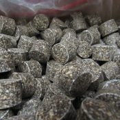
• HOME
  • About
    • Staff
    • Annual Plan of Work
    • Employee Handbook
    • Board of Directors
    • Price Schedule
  • Meetings
  • Contact
  • Calendar
  • Annual Reports
    • 2022 Annual Report (PDF)
    • 2021 Annual Report
    • 2020 Annual Report
    • 2019 Annual Report
    • 2018 Annual Report
    • 2017 Annual Report
    • 2016 Annual Report
  • Request Assistance

Wayne County Soil & Water Conservation District

7312 RT 31 Lyons, NY 14489 / 315-946-7200

Menu 
  • Programs
    • Ag Environmental Management (AEM)
      • Wayne Cnty AEM 2021-2025 Strategic Plan
      • AEM Program Overview (PDF)
      • AEM Tier I Worksheet (PDF)
      • AEM Farms in Wayne County
      • Case Studies
      • — Roseview Dairy Farm
      • — Hidden Canyon Farm
      • — Mouton Farms
      • — How-Bar Farms
    • Agriculture Drainage Assistance
      • Case Studies
      • — Middle Sodus Drainage Basin
      • — Dennison Creek Ontario, NY
      • — Four Mile Creek – Ontario, NY
    • Tree Sale
      • Tree Sale Reference Guide
      • Reference Photo Catalog
    • Wayne County Envirothon
      • Current Issue Study Guide
      • Aquatics Study Guide
      • Forestry Study Guide
      • Soils and Land Use Study Guide
      • Wildlife Study Guide
    • Critical Area Seeding
      • Critical Seeding Photos
      • Case Studies
      • –Galen and Walworth
    • NYS Grown and Certified
      • Grown and Certified FAQ
      • Where to Buy
      • Get Certified!
    • Water Quality Assessments
      • Clyde River Tributaries (PDF)
        Fairville Creek (PDF)
        Lower Ganargua (PDF)
        Red Creek East (PDF)
        Red Creek West (PDF)
        Upper Ganargua Creek (PDF)
        Lower Ganargua Creek (PDF)
        Maxwell Creek
        Salmon Creek
    • Pond Management & Fish Sale
      • Triploid Grass Carp Stocking Permit
      • Order Barley Straw
    • Septic System Replacement
    • Youth Fishing Derby
  • Services
    • Soil Health
      • Soil Health Testing Available
      • Soil Testing PRE Order Form (PDF)
      • AEM – Tier I Worksheet (PDF)
      • Call Ian 315-946-7200
      • Soil Health Case Studies
    • SG Worksheets
      • Are you in an Ag District?
      • Order Worksheet
    • Conservation No Till Drill Rental
    • Culvert Enhancement Services
    • Hydro-seeding Services
    • Soil Health Testing
    • Other Permitting Assistance
  • Education
    • Conservation
      • NY Natural History Projects
      • Why is ag. conservation important?
      • Conservation Landscaping
      • What is Green Infrastructure?
      • Soils & Erosion
        _________________________________
      • Living with Beavers
      • Understanding Soil
        • Composting Slide Show
        • Earth Worms & Soil
        • What is Soil?
        • Soil Health Matters
        • Fun With Soils
        • NRCS – Healthy Soils
        • Soil Classification Quiz
        • Water Diverter (Erosion Control)
    • Invasive Species
      • Finger Lakes PRISM
      • National Invasive Species Awareness Week
      • PLAY-Clean-GO
      • Invasive Species Guide & Fact Sheets
      • Invasive Species Activity Workbook
      • NY DEC Invasive Species Plan -2020
      • Integrated Pest Mgmt Database
      • K-12 Educator Resources
      • Finger Lakes PRISM events
      • BMP – Biology / Control of Aquatics (.pdf)
      • Weed Ecology – Cornell Edu
      • —FACT SHEETS—
        • Asian Long Horned Beetle
        • Black Swallowwort
        • Curly Leaved Pondweed
        • Emerald Ash Borer
        • Eurasian Water Milfoil
        • Hemlock Woolly Adelgid
        • Hydrilla
        • Japanese Knotweed
        • Kudzu
    • For Educators
      • K12 ACTIVITIES
      • Backyard Conservation
      • Interactive Water Cycle
      • Invasive Scavenger Hunt
      • Nonpoint Source Kids Page
      • Pollinator-Friendly Guides
      • Ronny the Rain Drop
      • Project Wild
      • Project WET
      • Sammy Soil Coloring Book
      • STEAM
      • Water Rocks!
      • Community Field Days
    • Water Quality
      • Field Guide to Aquatic Plants
      • FLLOWPA-Booklet
      • Harmful Algal Blooms (DEC)
      • 2015 Water Quality Strategy
      • The Hydrologic Cycle (PDF)
      • What is a watershed?
      • The Role of Wetlands
      • Build a Benthic Mat
      • Rain Gardens
      • Rain Barrels
      • Stormwater Basics
      • What is nonpoint source pollution?
      • Well Owners Guide Book
  • Resources
    • Agriculture
      • Ag & Farmland Protection Plan (PDF)
      • ACEP Ag Conservation Easement Program
      • AEM Strategic Plan (PDF)
      • Cornell Crop Alerts
      • USDA Weekly Crop Bulletin
      • Cornell Cover Crop Guide
      • USDA Cover Crop Trends .pdf
      • Midwest Regional Climate Center
      • FSA Conservation Programs
      • Herbicide Reference, Cornell
      • NYS Integrated Pest Management Center
      • NRCS Conservation Programs
      • Wayne Cnty Ag & Farmland Map PDF
      • Map of CAFO Permitted locations
      • CAFO Operations FAQ .PDF
      • _________________
      • Soil Resources
        • Soil Survey Wayne Cnty (PDF)
        • Soil Descriptions (PDF)
        • NY Soil Health News
        • Assessment- Soil Health
        • Soil Calculator
        • Drainage Guide NYS (PDF)
        • NRCS Soil Data Explorer
        • USDA From the Surface Down
    • Waterfront Partner Inititives
      • Coastal Lakeshore Economy and Resiliency initiative
      • Healthy Port Futures
      • Great Lakes Climate Resilience Portal
      • — LWRP Huron
      • — LWRP Macedon
      • — LWRP Sodus Point
      • — Port Bay (TMDL) P
      • Lake Ontario REDI
        • Port Bay REDI
        • Blind Sodus Bay Western Bluff
        • Blind Sodus Bay Eastern Bluff
        • Crescent Beach
      • Federal, State & Municipal
        • NY DEC Report an Environmental Violation
        • EPA Clean Water Enforcement
        • Ontario-Wayne Stormwater Coalition
        • NY DEC MS4 Forms
        • Managing Stormwater /Structural Soil & Trees (PDF)
      • Permitting
        PERMITTING LINKS BELOW
        • CEHA Management Permit Program
        • SHPA Review Request
        • Joint Application Form .PDF
        • US Army Corps – Permitting Office
        • NYS DEC Permitting Office
        • Environmental Notice Bulletin (ENB)
        • SPDES Permits
    • Maps & Charts
      • ARC GIS
      • Explorer.Pictometry
      • DEC Freshwater Wetland Mapper
      • FEMA – Map Viewer
      • Genesee Transportation Council Regional Map
      • Google Earth Engine Hydra Mapper
      • Great Lakes Restoration Coastal Wetlands Mapper
      • Historical Aerial photos
      • NYS Drainage Basin (PDF)
      • NYS Ortho Mapper
      • Wayne Cnty Watershed Map
      • NY Climate Science Clearing House
      • NY DEC Stormwater Mapping
      • NY Sea Grant – My Coast
      • NY State GIS Mapping
      • NOAA Now Coast
      • NOAA Digital Coast
      • NOAA Flood Exposure Mapper
      • Sodus Bay & Wolcott Wetland Maps (PDF)
      • USEPA Climate Change Adaptation Resources
      • USFWS Wetland Mapper
      • USGS flood inundation Mapper
      • USGS Water Data Mapper
      • USGS – Stream Stats Tool
      • USACE GL-Coastal Resiliency Study
  • Waterfronts
    • About the AVC Program
      • FAQ & Updates
      • AVC Policies (PDF)
      • AVC Operational Calendar
    • Living on a Waterfront
      • Home Owners Guide Book
      • Field Guide to Aquatic Plants
      • Erosion Management GL Shorelines
      • Effects of Coastal Erosion
      • What is a Living Shoreline? (NOAA)
      • SLELO – Aquatic Plant Guide
    • Water Quality Updates
    • Blue Green Algae
      • Report It, Avoid It! (PDF)
      • Blue Green Algae ID
    • Subscribe for WQ updates
    • Fl-lowpa Program Video (YouTube)
  • REDI
    • REDI Projects Overview
    • Port Bay REDI
    • Blind Sodus Bay Eastern Bar
    • Blind Sodus Bay Western Bluff
    • Crescent Beach REDI
  • Tree Sale
    • Conservation Packs
    • Habitat Boxes
    • Seed Mixes
    • Fertilizer, Tree Tubes & more
    • Pickup Dates
      Wednesday April 19, 2023 Noon-7 PM
      Thursday April 20, 2023 8:00 AM - 5:00 PM
      Friday April 21, 2023 8:00 AM - 5:00 PM
  • Recycle Event
  • 67. Fertilizer Tablets 20-10-5 Slow Release

    $0.10 – $10.00
    Select Quantity Quick View

Directions

Hours: M-F 7:30 - 4:00 P.M. 315-946-7200

Quick References

    Cornell Cooperative Extension
    FL-LOWPA

  • Finger Lakes PRISM
  • IMAP Invasive
  • Ontario Wayne Storm Water Coalition
  • NRCS
  • NY Department of State
  • NYS DEC
  • NYS Department of Health

News and Updates

Enter your email address to subscribe. You will receive notifications of news and updates delivered by e-mail.

Sign Up!

round white

Check your inbox or spam folder now to confirm your subscription.

© 2012-2023 Wayne County Soil & Water Conservation District
Copyright © 2023 Log in
Wayne County Soil and Water Conservation District
7312 RT 31 Lyons, NY 14489
315-946-7200

Scroll Up
  • Programs
    ▼
    • Ag Environmental Management (AEM)
      ▼
      • Wayne Cnty AEM 2021-2025 Strategic Plan
      • AEM Program Overview (PDF)
      • AEM Tier I Worksheet (PDF)
      • AEM Farms in Wayne County
      • Case Studies
      • — Roseview Dairy Farm
      • — Hidden Canyon Farm
      • — Mouton Farms
      • — How-Bar Farms
    • Agriculture Drainage Assistance
      ▼
      • Case Studies
      • — Middle Sodus Drainage Basin
      • — Dennison Creek Ontario, NY
      • — Four Mile Creek – Ontario, NY
    • Tree Sale
      ▼
      • Tree Sale Reference Guide
      • Reference Photo Catalog
    • Wayne County Envirothon
      ▼
      • Current Issue Study Guide
      • Aquatics Study Guide
      • Forestry Study Guide
      • Soils and Land Use Study Guide
      • Wildlife Study Guide
    • Critical Area Seeding
      ▼
      • Critical Seeding Photos
      • Case Studies
      • –Galen and Walworth
    • NYS Grown and Certified
      ▼
      • Grown and Certified FAQ
      • Where to Buy
      • Get Certified!
    • Water Quality Assessments
      ▼
      • Assessments
    • Pond Management & Fish Sale
      ▼
      • Triploid Grass Carp Stocking Permit
      • Order Barley Straw
    • Septic System Replacement
    • Youth Fishing Derby
  • Services
    ▼
    • Soil Health
      ▼
      • Soil Health Testing Available
      • Soil Testing PRE Order Form (PDF)
      • AEM – Tier I Worksheet (PDF)
      • Call Ian 315-946-7200
      • Soil Health Case Studies
    • SG Worksheets
      ▼
      • Are you in an Ag District?
      • Order Worksheet
    • Conservation No Till Drill Rental
    • Culvert Enhancement Services
    • Hydro-seeding Services
    • Soil Health Testing
    • Other Permitting Assistance
  • Education
    ▼
    • Conservation
      ▼
      • NY Natural History Projects
      • Why is ag. conservation important?
      • Conservation Landscaping
      • What is Green Infrastructure?
      • Soils & Erosion
      • Living with Beavers
      • Understanding Soil
        ▼
        • Composting Slide Show
        • Earth Worms & Soil
        • What is Soil?
        • Soil Health Matters
        • Fun With Soils
        • NRCS – Healthy Soils
        • Soil Classification Quiz
        • Water Diverter (Erosion Control)
    • Invasive Species
      ▼
      • Finger Lakes PRISM
      • National Invasive Species Awareness Week
      • PLAY-Clean-GO
      • Invasive Species Guide & Fact Sheets
      • Invasive Species Activity Workbook
      • NY DEC Invasive Species Plan -2020
      • Integrated Pest Mgmt Database
      • K-12 Educator Resources
      • Finger Lakes PRISM events
      • BMP – Biology / Control of Aquatics (.pdf)
      • Weed Ecology – Cornell Edu
      • —FACT SHEETS—
      • Invasive Species Fact Sheets
    • For Educators
      ▼
      • K12 ACTIVITIES
      • Backyard Conservation
      • Interactive Water Cycle
      • Invasive Scavenger Hunt
      • Nonpoint Source Kids Page
      • Pollinator-Friendly Guides
      • Ronny the Rain Drop
      • Project Wild
      • Project WET
      • Sammy Soil Coloring Book
      • STEAM
      • Water Rocks!
      • Community Field Days
    • Water Quality
      ▼
      • Field Guide to Aquatic Plants
      • FLLOWPA-Booklet
      • Harmful Algal Blooms (DEC)
      • 2015 Water Quality Strategy
      • The Hydrologic Cycle (PDF)
      • What is a watershed?
      • The Role of Wetlands
      • Build a Benthic Mat
      • Rain Gardens
      • Rain Barrels
      • Stormwater Basics
      • What is nonpoint source pollution?
      • Well Owners Guide Book
  • Resources
    ▼
    • Agriculture
      ▼
      • Ag & Farmland Protection Plan (PDF)
      • ACEP Ag Conservation Easement Program
      • AEM Strategic Plan (PDF)
      • Cornell Crop Alerts
      • USDA Weekly Crop Bulletin
      • Cornell Cover Crop Guide
      • USDA Cover Crop Trends .pdf
      • Midwest Regional Climate Center
      • FSA Conservation Programs
      • Herbicide Reference, Cornell
      • NYS Integrated Pest Management Center
      • NRCS Conservation Programs
      • Wayne Cnty Ag & Farmland Map PDF
      • Map of CAFO Permitted locations
      • CAFO Operations FAQ .PDF
      • _________________
      • Soil
        ▼
        • Soil Survey Wayne Cnty (PDF)
        • Soil Descriptions (PDF)
        • NY Soil Health News
        • Assessment- Soil Health
        • Soil Calculator
        • Drainage Guide NYS (PDF)
        • NRCS Soil Data Explorer
        • USDA From the Surface Down
    • Waterfront Partner Inititives
      ▼
      • Coastal Lakeshore Economy and Resiliency initiative
      • Healthy Port Futures
      • Great Lakes Climate Resilience Portal
      • — LWRP Huron
      • — LWRP Macedon
      • — LWRP Sodus Point
      • — Port Bay (TMDL) P
      • Lake Ontario REDI
        ▼
        • Port Bay REDI
        • Blind Sodus Bay Western Bluff
        • Blind Sodus Bay Eastern Bluff
        • Crescent Beach
      • Federal, State & Municipal
        ▼
        • NY DEC Report an Environmental Violation
        • EPA Clean Water Enforcement
        • Ontario-Wayne Stormwater Coalition
        • NY DEC MS4 Forms
        • Managing Stormwater /Structural Soil & Trees (PDF)
      • Permitting
        ▼
        • CEHA Management Permit Program
        • SHPA Review Request
        • Joint Application Form .PDF
        • US Army Corps – Permitting Office
        • NYS DEC Permitting Office
        • Environmental Notice Bulletin (ENB)
        • SPDES Permits
    • Maps & Charts
      ▼
      • ARC GIS
      • Explorer.Pictometry
      • DEC Freshwater Wetland Mapper
      • FEMA – Map Viewer
      • Genesee Transportation Council Regional Map
      • Google Earth Engine Hydra Mapper
      • Great Lakes Restoration Coastal Wetlands Mapper
      • Historical Aerial photos
      • NYS Drainage Basin (PDF)
      • NYS Ortho Mapper
      • Wayne Cnty Watershed Map
      • NY Climate Science Clearing House
      • NY DEC Stormwater Mapping
      • NY Sea Grant – My Coast
      • NY State GIS Mapping
      • NOAA Now Coast
      • NOAA Digital Coast
      • NOAA Flood Exposure Mapper
      • Sodus Bay & Wolcott Wetland Maps (PDF)
      • USEPA Climate Change Adaptation Resources
      • USFWS Wetland Mapper
      • USGS flood inundation Mapper
      • USGS Water Data Mapper
      • USGS – Stream Stats Tool
      • USACE GL-Coastal Resiliency Study
  • Waterfronts
    ▼
    • About the AVC Program
      ▼
      • FAQ & Updates
      • AVC Policies (PDF)
      • AVC Operational Calendar
    • Living on a Waterfront
      ▼
      • Home Owners Guide Book
      • Field Guide to Aquatic Plants
      • Erosion Management GL Shorelines
      • Effects of Coastal Erosion
      • What is a Living Shoreline? (NOAA)
      • SLELO – Aquatic Plant Guide
    • Water Quality Updates
    • Blue Green Algae
      ▼
      • Report It, Avoid It! (PDF)
      • Blue Green Algae ID
    • Subscribe for WQ updates
    • Fl-lowpa Program Video (YouTube)
  • REDI
    ▼
    • REDI Projects Overview
    • Port Bay REDI
    • Blind Sodus Bay Eastern Bar
    • Blind Sodus Bay Western Bluff
    • Crescent Beach REDI
  • Tree Sale
    ▼
    • Conservation Packs
    • Habitat Boxes
    • Seed Mixes
    • Fertilizer, Tree Tubes & more
    • Pickup Dates
  • Recycle Event